
Long floors and old stairs
- Mark every stair that leads down and out, including any added in a later renovation.
- Plan on the stairs, not a freight elevator.
- Show where a long corridor turns or narrows, so nobody walks into a dead end.
Free fire escape plan · North Carolina
Take a photo of the plan, or sketch one, for a North Carolina home, shop or converted-mill unit, and the free generator marks exits, routes and a meeting point on it. Read on for NC OSH, the state codes, storms and inland flooding, the old textile mills that now hold shops and offices, and the fire departments in the three largest cities.
A planning draft, not an inspection or approval. NC OSH, your local fire department and your building inspector decide what applies to you.
NC OSH and the state fire marshal
North Carolina runs its own OSHA state plan: OSHA’s page for it says the NC OSH Division covers private-sector workplaces in the state, with listed exceptions (OSHA). Building and fire codes are posted by the Office of State Fire Marshal (NC OSFM).
OSHA says the NC OSH Division covers private-sector workplaces in North Carolina, apart from the exceptions it lists (OSHA). Ask NC OSH if you are not sure which agency covers your business.
State law has pushed back the start of the 2024 North Carolina State Building Code more than once, so the Office of State Fire Marshal’s codes page is the place to check which edition is in force (NC OSFM).
Inspections, permits and questions about a particular building go to the local fire department. The city table further down links to three of them.
In much of North Carolina, the map that shows the way out in a fire can also show where to go when water rises: mark which doors and parts of the lot stay dry and where people gather on higher ground.
Old mills, new tenants
Many of North Carolina’s old brick textile mills now hold shops, offices, studios and apartments. They have long floors, stairs added at different times and many tenants, so a good map shows the way out from each space, not only the building’s front door.
Assembly point · the generator
A floor plan from a mill renovation, a phone photo of a hand sketch or a PDF of a shop works. The draft adds routes, exits, safety symbols and a meeting point; the flood side of the lot and the high ground can go on as labels in the editor.
Drag & drop your floor plan here
or
PNG, JPG, HEIC, TIFF, BMP, SVG, AVIF, WebP, PDF, DOC, DOCX, PPT, PPTX, XLS, XLSX, ODT, ODP, ODS, DXF, DWG - Hand-drawn sketches work too!
No floor plan handy? Try the included floor plan with real AI generation — no upload needed. This may take a minute or longer.
Yes — you can generate your first OSHA-aligned evacuation map draft completely free. Just upload a floor plan and our AI drafts a professional map in about 30 seconds. No credit card required.
Our AI drafts maps that follow OSHA 29 CFR 1910.36–37 and NFPA 101 Life Safety Code standards. Every map includes clearly marked exits, fire extinguisher locations, assembly points, and directional evacuation arrows. Supervisor review is required before posting to your facility.
We accept PNG, JPG, GIF, WebP, BMP, TIFF, AVIF, HEIC, SVG, PDF, DOC/DOCX, PPT/PPTX, XLS/XLSX, ODT, ODP, ODS, DXF, and DWG floor plans. Office and CAD files are converted securely before processing; PDF uploads let you choose the source page.
Most maps are generated in 20–40 seconds. Complex multi-floor plans may take slightly longer. You see the preview instantly — create a free account (no credit card) to download the file.
Yes — every generated map opens in a free drag-and-drop editor where you can move, resize, and recolor exit signs, routes, and equipment icons. Enterprise features like multi-floor support and branded maps are available on paid plans.
Yes. All uploads are encrypted in transit (TLS 1.3) and processed in secure cloud environments. We do not share your floor plans with third parties.
Every result is a draft. Walk each route, and the way up to the meeting point, before you post it.
Before and after
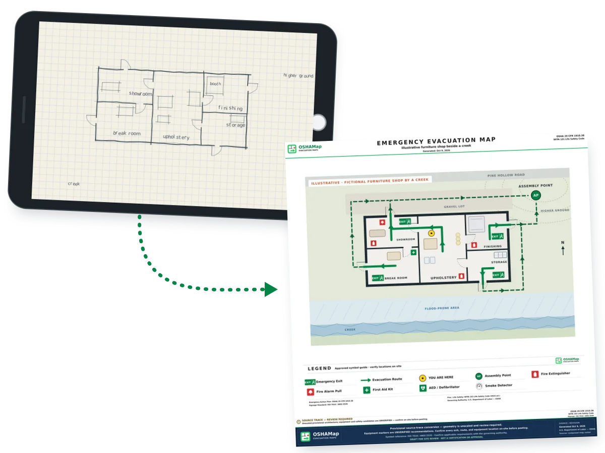
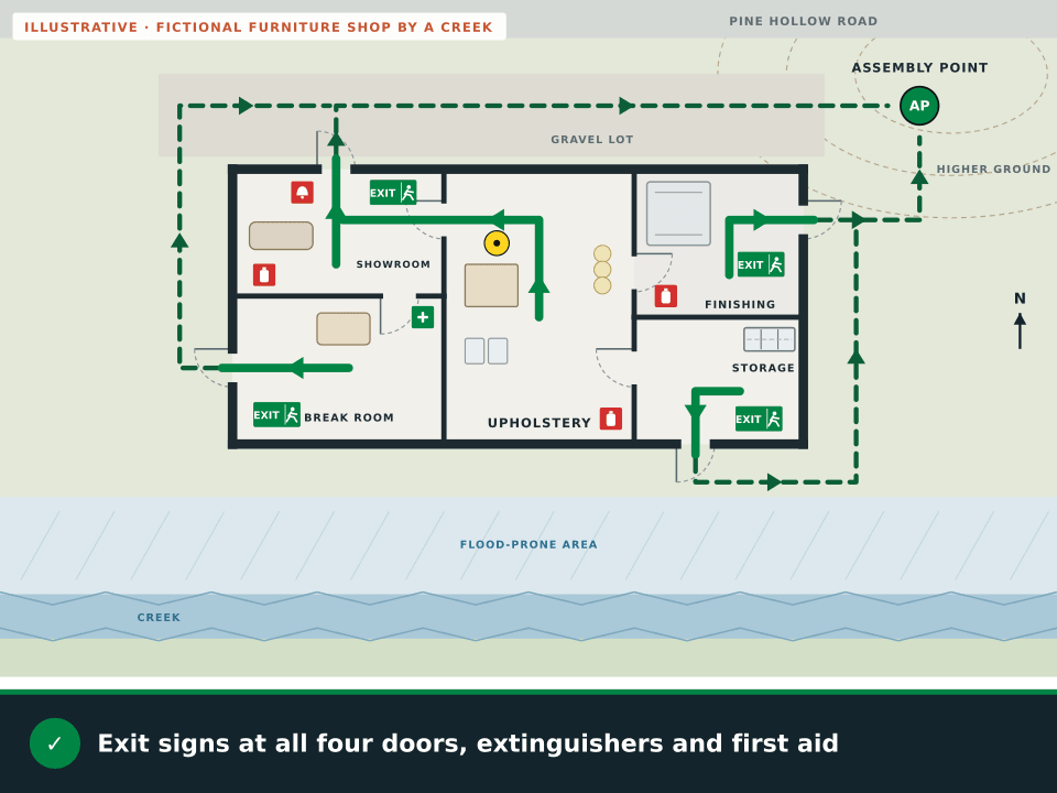
The plain plan shows a one-story furniture shop beside a creek: a showroom, a break room, an upholstery room, a finishing room with a spray booth and a storage room, with the front door facing uphill and the back door facing the flood-prone side. The draft routes each room to the nearest door and every outside route up to a meeting point on higher ground.


What the draft adds to a creek-side shop plan
Hurricanes and inland flooding
Hurricane Helene in 2024 showed how far inland the danger can reach: the National Hurricane Center reports historic rainfall in the southern Appalachians, catastrophic flooding and widespread landslides, with the French Broad River at Asheville cresting at 24.8 feet, above the 23.1 feet it reached in 1916 (National Hurricane Center).
Charlotte, Raleigh, Greensboro
Each of these departments handles inspections and fire code questions in one of North Carolina’s three largest cities. Start with the one that serves your address.
| City | Residents (2024 est.) | Question to start with | Department link |
|---|---|---|---|
| Charlotte | 943,476 | How a tenant in a converted mill should share exits with the other tenants. | Charlotte Fire Department |
| Raleigh | 499,825 | What to check at a shop near a creek before hurricane season. | Raleigh Fire Department |
| Greensboro | 307,381 | How often a plant with several floors should practice a drill. | Greensboro Fire Department |
Population figures are U.S. Census Bureau Vintage 2024 estimates (Census Bureau). Durham, at 301,870, is fourth. In smaller towns and rural areas, start with your local fire department.
Keep planning
Guides for trades that renovate and service North Carolina buildings, two more states with hurricane seasons and the North Carolina workplace page.
Questions
Yes. Upload the plan of a creek-side shop or a mill unit, a photo of it or a sketch of your home, and you’ll see a watermarked preview with no account. A free account costs nothing, needs no credit card and includes 5 free floor-plan uploads per month, with up to 5 regenerations per upload and the editor. Exports are marked as drafts until the posting review is done.
For most private employers, the NC OSH Division. OSHA says the NC OSH Division covers private-sector workplaces in the state, with the exceptions it lists.
Check the Office of State Fire Marshal’s codes page. The start of the 2024 North Carolina State Building Code has been delayed by state law more than once, so that page is the best place to confirm the edition in force.
Uphill and away from the low side of the lot. Ready.gov says to move to higher ground in a flood and warns that just six inches of moving water can knock you down, so the way to the meeting point should never cross a low spot.
Show your unit on a plan of the whole floor, mark every stair down and out, including any added in renovations, and share the meeting point with the other tenants so everyone gathers in one place.
It helps. Ready.gov advises knowing your evacuation zone, learning and practicing the routes and deciding where you will stay, and leaving right away if local officials tell your mandatory evacuation zone to go.
Illustrations on this page use fictional layouts made for this page. They are not customer plans or live generator results.
Ready? Upload your North Carolina shop, mill unit or home plan and see the free draft.
Draft my North Carolina plan
