(775) 317-4488|Need help with your map? Call or chat with us!support@oshamap.comPartners & Joint Ventures
🏙️
MN

Minneapolis Evacuation Maps: MN OSHA

Twin Cities workplace compliance with winter considerations.

Get Minnesota OSHA-aligned evacuation maps for Minneapolis businesses in a minute or two, with cold-weather assembly points. Free.

👥Population430,000
🏭Key Industrieshealthcare, finance, food-processing
Free preview • No credit card required

Generate Your Evacuation Map

Upload your floor plan to create a professional OSHA-aligned evacuation map.

📊 5 Free Maps Left

Create Your Evacuation Map

See the safety plan from every angleWatch a sketch become a polished map, then step inside.Watch demo Need to start from a rough layout?Sketch rooms and exits, then turn it into a clear safety map.Draw your map
✏️
High ContrastUse dark ink on white paper. Bold lines help our AI detect walls accurately
📐
Top-Down AnglePhotograph from directly above — tilted photos bend the walls out of shape
🏷️
Label RoomsWrite "Exit", "Storage", "Breakroom" etc. — our AI reads your labels for compliance
🔍
Full Floor PlanCapture the entire layout including all walls, doors, and exits — no cropping
🚪
Mark ExitsCircle or label exit doors with a red dot or "EXIT" text for best detection
💡
Good LightingAvoid shadows and glare — even lighting produces the sharpest results
Your plan opens in the editor right away. You place the exits, routes and safety equipment. Hand sketches go to AI generation instead, to be redrawn as a clean plan.
📁

Drag & drop your floor plan here

or

PNG, JPG, HEIC, TIFF, BMP, SVG, AVIF, WebP, PDF, DOC, DOCX, PPT, PPTX, XLS, XLSX, ODT, ODP, ODS, DXF, DWG - Hand-drawn sketches work too!

or

No floor plan handy? Try the included floor plan with real AI generation — no upload needed. This may take a minute or longer.

Edit your map for free.
Move, resize, and recolor every exit sign, route, and icon.
Create a free account to save and download in HD. No credit card required.
FREE
🔒Your files are private: never shared, stored temporarily, deleted automatically.

Compliance Options

Choose your floor plan to open it in the editor.

Frequently Asked Questions

Is this evacuation map generator really free?

Yes — you can generate your first OSHA-aligned evacuation map draft completely free. Just upload a floor plan and our AI drafts a professional map in about 30 seconds. No credit card required.

Are the generated maps aligned with OSHA?

Our AI drafts maps that follow OSHA 29 CFR 1910.36–37 and NFPA 101 Life Safety Code standards. Every map includes clearly marked exits, fire extinguisher locations, assembly points, and directional evacuation arrows. Supervisor review is required before posting to your facility.

What file formats can I upload?

We accept PNG, JPG, GIF, WebP, BMP, TIFF, AVIF, HEIC, SVG, PDF, DOC/DOCX, PPT/PPTX, XLS/XLSX, ODT, ODP, ODS, DXF, and DWG floor plans. Office and CAD files are converted securely before processing; PDF uploads let you choose the source page.

How long does map generation take?

Most maps are generated in 20–40 seconds. Complex multi-floor plans may take slightly longer. You see the preview instantly — create a free account (no credit card) to download the file.

Can I edit the map after generation?

Yes — every generated map opens in a free drag-and-drop editor where you can move, resize, and recolor exit signs, routes, and equipment icons. Enterprise features like multi-floor support and branded maps are available on paid plans.

Is my floor plan data secure?

Yes. All uploads are encrypted in transit (TLS 1.3) and processed in secure cloud environments. We do not share your floor plans with third parties.

📍Local Requirements

Minneapolis Workplace Safety Requirements

⚖️

Minneapolis businesses must comply with Minnesota OSHA and consider winter weather impacts on evacuation, including icy conditions at outdoor assembly points and skyway-connected buildings.

Evacuation Planning in Minneapolis

Downtown Minneapolis is famously stitched together by roughly nine and a half miles of enclosed skyways linking towers, so an evacuation question that is simple elsewhere, where do people go, gets more complicated here. Add major corporate headquarters, healthcare systems, finance, and food-processing operations, and the metro's building mix is unusually varied.

Minnesota operates its own state OSHA program, MNOSHA, so Minneapolis employers follow MNOSHA standards, including emergency-action-plan requirements, with the Minneapolis Fire Department enforcing local fire codes. The skyway network means routes and assembly points have to be planned across connected buildings, not just one.

The dominant local factor is extreme cold: sub-zero winter temperatures make a standard outdoor assembly point genuinely dangerous. From your floor plan, OSHAMap generates a posting-ready evacuation map with exits, routes, and assembly points already placed, for a skyway-connected tower or a processing plant in minutes.

Minneapolis Evacuation Challenges

Local factors to account for when planning your routes and assembly points

Skyway-connected buildings

Skyways can serve as a sheltered route or complicate which building people exit into. Maps should clearly show whether to use the skyway or reach the street, and coordinate assembly points across connected buildings.

Extreme-cold assembly

Sub-zero temperatures make standing outside for a head count dangerous. Designate a warm indoor alternate assembly area and mark the route to it, since an outdoor-only plan can fail in a Minnesota winter.

Corporate HQ towers

Large headquarters towers carry big populations and need stairwell and refuge-floor planning. Mark stair identifiers and refuge areas for orderly full or phased evacuation.

Food-processing facilities

Refrigeration systems can use ammonia and other hazards sit along egress paths. Route people clear of process and refrigeration areas, with assembly points away from those zones.

FROM FLOOR PLAN TO REVIEW-READY DRAFT

Keep the building familiar.
Make the safety story legible.

OSHAMap turns the layout you already have into an editable OSHA-aligned draft—so a safety professional can focus on verification, not redrawing.

01 / SOURCE

Start with what you have.

A floor-plan PDF, phone photo, or hand sketch gives the draft a place to begin.

Upload PDF, image, or sketchEditable safety elementsExport after review
YOUR SOURCE
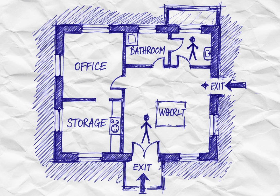
Hand-drawn workplace floor planPDF · photo · sketch
ILLUSTRATIVE EDITABLE DRAFT
The same hand-drawn workplace floor plan with an illustrative editable safety layer
Review before posting
Built for reviewConfirm site-specific routes and equipment.
Designed to editMove, resize, and adjust visual safety elements.
Ready to shareExport the reviewed draft as PDF, PNG, or SVG.

AI Creates the Draft. Your Safety Team Makes It Site-Ready.

Faster first drafts. Human-reviewed decisions. Safer U.S. workplaces.

INSIDE THE EDITING EXPERIENCE

AI creates the first draft.Your team stays in control.

The automation gets you to a strong starting point. The editor keeps your team in control of site-specific details.

WALKTHROUGHEvacuation map · editable draft
EDITABLE DRAFT
REVIEW CHECKVerify exit routeConfirm this path reflects the current facility.READY FOR REVIEW
EXPORT REVIEWED DRAFT
PDFPNGSVG

01 / 04 · Open draft

Your generated draft opens in the editor.

Start from the OSHA-aligned map draft and keep the building layout in view while you review each safety element.

OSHAMap creates an OSHA-aligned draft for review. Your safety team or AHJ should verify the final map before posting.

Why Minneapolis Businesses Choose Our AI Map Generator

Do I need design skills to create an evacuation map?

No design skills are required. Our AI understands hand-drawn floor plans, smartphone photos, scanned blueprints, and PDF documents. Simply upload any representation of your facility layout and receive a professional-grade emergency evacuation map instantly.

Are the generated maps OSHA-aligned?

OSHAMap is designed to help users organize key evacuation-planning information commonly associated with OSHA 29 CFR 1910.38 — clearly marked exit routes, fire extinguisher locations within 75-foot travel distance, assembly points, YOU ARE HERE markers, and accessibility accommodations per ADA guidelines. Each draft must be reviewed and verified for the actual workplace by the employer, safety officer, or AHJ before posting.

Can I update my evacuation map after renovations?

Yes. If you renovate your office or add an emergency exit, re-upload the updated floor plan and create a new draft for review. Free accounts include up to 5 regenerations per upload; verify each revision against the workplace before posting.

What types of buildings can use this evacuation map generator?

Our generator works for any building type including warehouses, manufacturing plants, healthcare facilities, schools, retail stores, and office buildings. The AI adapts to any facility size and layout, generating appropriate exit routes, fire safety equipment placement, and assembly point locations.

Key Industries in Minneapolis

Specialized evacuation planning for Minneapolis's major industries

healthcarefinancefood-processingtechnologyretail

Why Minneapolis Businesses Choose OSHAMap

⏱️

Save Time

Generate maps in under 2 minutes instead of waiting weeks for consultants

💰

Save Money

Skip the $500-$2,000 consultant fees per map

✅

Minnesota Compliant

Maps meet MN state requirements and local fire codes

📋

Audit Ready

Impress local inspectors with professional documentation

🔓 Free Account Bonus

Unlock 5 Free Floor-Plan Uploads Per Month

Create your free account to access professional, OSHA-aligned evacuation-map drafts for review.

What You Get When You Register:

  • ✓ 5 Free Floor-Plan Uploads Per Month + Up to 5 Regenerations Per Upload - Professional maps ready for printing
  • ✓ No Watermarks - Clean, presentation-ready evacuation maps
  • ✓ Personal Dashboard - Manage all your maps in one place
  • ✓ Save & Revisit Anytime - Access your maps from any device
  • ✓ OSHA-Aligned - Meets 29 CFR 1910.38 requirements
15,000+Maps Generated
100%Compliant
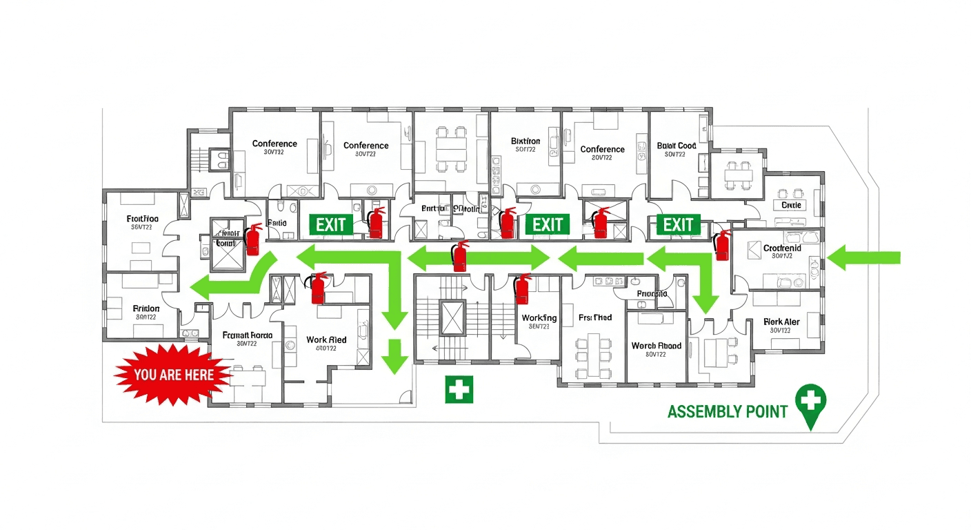
Sample Output
Sample Minnesota OSHA-aligned evacuation floor plan showing emergency exits, fire extinguisher locations, and assembly points
🧯 Fire Extinguishers🚪 Exit Routes📍 You Are Here

No credit card required • Free account • Access your map drafts for review

Frequently Asked Questions About Minneapolis Compliance

What OSHA standards apply to businesses in Minneapolis, MN?

Minneapolis businesses must comply with Minnesota OSHA and consider winter weather impacts on evacuation, including icy conditions at outdoor assembly points and skyway-connected buildings.

How can Minneapolis businesses create OSHA-aligned evacuation maps quickly?

Our AI-powered map generator creates professional, OSHA-aligned evacuation maps in under 2 minutes. Simply upload your floor plan, and we'll automatically include all required elements for Minnesota compliance.

Are there special fire safety requirements in Minneapolis?

Minneapolis businesses must comply with both Minnesota state regulations and local fire department requirements. Minneapolis businesses must comply with Minnesota OSHA and consider winter weather impacts on evacuation, including icy conditions at outdoor assembly points and skyway-connected buildings. Our maps are designed to meet all applicable standards.

Will my evacuation map pass an inspection in Minneapolis?

Yes! Our maps include all required elements for Minnesota compliance including clearly marked exit routes, fire extinguisher locations, assembly points, and "You Are Here" markers. Maps are designed to meet federal, state, and local requirements.

Is Minneapolis under MNOSHA or federal OSHA?

Minnesota operates its own state OSHA plan, MNOSHA, so Minneapolis employers follow MNOSHA standards, including emergency-action-plan requirements. A posted evacuation map with marked exits, routes, and assembly areas demonstrates compliance, alongside Minneapolis Fire Department fire-code requirements.

How do downtown skyways affect Minneapolis evacuation planning?

The skyway network can act as a sheltered evacuation route or can blur which building people end up in, so the posted map should make the intended path explicit. Plan and coordinate assembly points across connected buildings, and decide in advance when staff should use the skyway versus exit to the street.

How should Minneapolis businesses handle assembly points in extreme cold?

Because sub-zero temperatures make an outdoor head count dangerous, designate a warm indoor alternate assembly area in addition to any outdoor point. Mark the route to it on the posted map and keep that path accessible throughout the winter.

Explore Other Major Cities

Ready to Comply with Minneapolis Safety Requirements?

Join thousands of Minneapolis businesses using OSHAMap.