(775) 317-4488|Need help with your map? Call or chat with us!support@oshamap.com
🛡️
Industry-Specific Compliance MapsAI-generated evacuation maps tailored to your facility type.

Q: What OSHA standards apply to government evacuation maps?

Quick Answer:

Applicability depends on the facility's actual operations and hazards; a generic industry standard list cannot determine the duty. 29 CFR 1910.38 applies only when another covered OSHA standard requires an EAP, and federal OSHA does not universally require a posted map. Verify any map content with the adopted code, permit, license, insurer, and AHJ.

🏛️

Government Fire Evacuation Maps (OSHA 2026)

Last reviewed: June 8, 2026 · Reviewed by OSHAMap Safety Editorial Team · Review with a qualified safety professional when required.

Public Sector Safety - Create Compliant Maps in Seconds

Government building evacuation plans meeting federal standards. Generate professional maps free and instant with our AI-powered map maker.

Free instant preview • No credit card • Download in seconds
3 Simple Steps:
1Upload Floor Plan
→
2Select State & Industry
→
3Get Your Map

Get Your Free OSHA Risk Assessment

Identify compliance gaps specific to Government in minutes. Our quick assessment helps you understand your evacuation planning requirements.

Start Free Assessment
Pre-upload field brief

Start with the floor plan.
Bring the site context.

We have preloaded the planning context for Government. Take a minute to compare it with the facility before you upload.

Map draft inputGovernment facility
0/3 checked

Site context to have at hand

  • Security threats
  • Public access areas
  • Historic buildings

These are prompts from the selected industry, not findings about your facility. Confirm conditions against the actual site and your emergency procedures.

01 Upload a legible floor plan. The draft is a starting point for qualified review, not a compliance determination.

Government Workplace Safety Compliance Generator

Upload your floor plan and get a professional OSHA-aligned government evacuation map in seconds

📊 5 Free Maps Left

Create Your Government Evacuation Map

See the safety plan from every angleWatch a sketch become a polished map, then step inside.Watch demo Need to start from a rough layout?Sketch rooms and exits, then turn it into a clear safety map.Draw your map
✏️
High ContrastUse dark ink on white paper. Bold lines help our AI detect walls accurately
📐
Top-Down AnglePhotograph from directly above — tilted angles distort the geometry
🏷️
Label RoomsWrite "Exit", "Storage", "Breakroom" etc. — our AI reads your labels for compliance
🔍
Full Floor PlanCapture the entire layout including all walls, doors, and exits — no cropping
🚪
Mark ExitsCircle or label exit doors with a red dot or "EXIT" text for best detection
💡
Good LightingAvoid shadows and glare — even lighting produces the sharpest results
📁

Drag & drop your floor plan here

or

PNG, JPG, HEIC, TIFF, BMP, SVG, AVIF, WebP, PDF, DOC, DOCX, PPT, PPTX, XLS, XLSX, ODT, ODP, ODS, DXF, DWG - Hand-drawn sketches work too!

or

No floor plan handy? Try the included floor plan with real AI generation — no upload needed. This may take a minute or longer.

Edit your map for free.
Move, resize, and recolor every exit sign, route, and icon.
Create a free account to save and download in HD. No credit card required.
FREE
🔒Your files are private: never shared, stored temporarily, deleted automatically.

Compliance Options

🔥 NEW✨

Customize Your Map

Add special requests for your safety map - tell our AI exactly what you need!

  • 🎯Add specific details like "Mark fire extinguisher near kitchen"
  • 📍Request specific zones: "Highlight assembly point in parking lot"
  • 🏥Add safety equipment: "Include AED location near reception"
0/2000

Quick Add:

Automatic (recommended)

Redraw the architecture from your floor plan first, then add editable safety markings. The original upload remains a reference, not the map background.

Frequently Asked Questions

Is this evacuation map generator really free?

Yes — you can generate your first OSHA-aligned evacuation map draft completely free. Just upload a floor plan and our AI drafts a professional map in about 30 seconds. No credit card required.

Are the generated maps aligned with OSHA?

Our AI drafts maps that follow OSHA 29 CFR 1910.36–37 and NFPA 101 Life Safety Code standards. Every map includes clearly marked exits, fire extinguisher locations, assembly points, and directional evacuation arrows. Supervisor review is required before posting to your facility.

What file formats can I upload?

We accept PNG, JPG, GIF, WebP, BMP, TIFF, AVIF, HEIC, SVG, PDF, DOC/DOCX, PPT/PPTX, XLS/XLSX, ODT, ODP, ODS, DXF, and DWG floor plans. Office and CAD files are converted securely before processing; PDF uploads let you choose the source page.

How long does map generation take?

Most maps are generated in 20–40 seconds. Complex multi-floor plans may take slightly longer. You see the preview instantly — create a free account (no credit card) to download the file.

Can I edit the map after generation?

Yes — every generated map opens in a free drag-and-drop editor where you can move, resize, and recolor exit signs, routes, and equipment icons. Enterprise features like multi-floor support and branded maps are available on paid plans.

Is my floor plan data secure?

Yes. All uploads are encrypted in transit (TLS 1.3) and processed in secure cloud environments. We do not share your floor plans with third parties.

FROM FLOOR PLAN TO REVIEW-READY DRAFT

Keep the building familiar.
Make the safety story legible.

OSHAMap turns the layout you already have into an editable OSHA-aligned draft—so a safety professional can focus on verification, not redrawing.

01 / SOURCE

Start with what you have.

A floor-plan PDF, phone photo, or hand sketch gives the draft a place to begin.

Upload PDF, image, or sketchEditable safety elementsExport after review
YOUR SOURCE
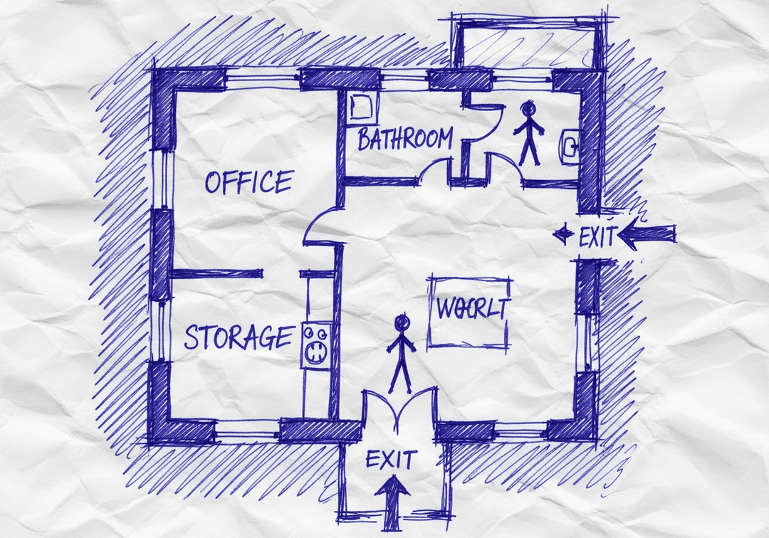
Hand-drawn workplace floor planPDF · photo · sketch
ILLUSTRATIVE EDITABLE DRAFT
The same hand-drawn workplace floor plan with an illustrative editable safety layer
Review before posting
Built for reviewConfirm site-specific routes and equipment.
Designed to editMove, resize, and adjust visual safety elements.
Ready to shareExport the reviewed draft as PDF, PNG, or SVG.

AI Creates the Draft. Your Safety Team Makes It Site-Ready.

Faster first drafts. Human-reviewed decisions. Safer U.S. workplaces.

INSIDE THE EDITING EXPERIENCE

AI creates the first draft.Your team stays in control.

The automation gets you to a strong starting point. The editor keeps your team in control of site-specific details.

WALKTHROUGHEvacuation map · editable draft
EDITABLE DRAFT
REVIEW CHECKVerify exit routeConfirm this path reflects the current facility.READY FOR REVIEW
EXPORT REVIEWED DRAFT
PDFPNGSVG

01 / 04 · Open draft

Your generated draft opens in the editor.

Start from the OSHA-aligned map draft and keep the building layout in view while you review each safety element.

OSHAMap creates an OSHA-aligned draft for review. Your safety team or AHJ should verify the final map before posting.

Why Government Professionals Choose Our AI Map Generator

Do I need design skills to create an evacuation map?

No design skills are required. Our AI understands hand-drawn floor plans, smartphone photos, scanned blueprints, and PDF documents. Simply upload any representation of your facility layout and receive a professional-grade emergency evacuation map instantly.

Are the generated maps OSHA-aligned?

OSHAMap is designed to help users organize key evacuation-planning information commonly associated with OSHA 29 CFR 1910.38 — clearly marked exit routes, fire extinguisher locations within 75-foot travel distance, assembly points, YOU ARE HERE markers, and accessibility accommodations per ADA guidelines. Each draft must be reviewed and verified for the actual workplace by the employer, safety officer, or AHJ before posting.

Can I update my evacuation map after renovations?

Yes. If you renovate your office or add an emergency exit, re-upload the updated floor plan and create a new draft for review. Free accounts include up to 5 regenerations per upload; verify each revision against the workplace before posting.

What types of buildings can use this evacuation map generator?

Our generator works for any building type including warehouses, manufacturing plants, healthcare facilities, schools, retail stores, and office buildings. The AI adapts to any facility size and layout, generating appropriate exit routes, fire safety equipment placement, and assembly point locations.

Industry-Specific Expertise

Government Safety: Serving the Public While Protecting Employees

Operational safety insights designed specifically for Government professionals

Operational Realities & Best Practices

Public Access
Challenge:Buildings open to public with varying behaviors
Best Practice:Security screening and controlled access points
Political Sensitivity
Challenge:Emergencies may attract attention
Best Practice:Communication protocols and media coordination
Historic Buildings
Challenge:Many government buildings are historic structures
Best Practice:Code-compliant retrofits and enhanced systems

Safety-Integrated Workflow

1
Building Opening
Security and safety systems check
✓Safe environment before public arrives
2
Public Hours
Staff awareness of emergency procedures
✓Ready to assist public during emergencies
3
Building Closing
Public clearance and securing
✓Safe handoff to after-hours security

Critical Equipment Zones & Requirements

Public Service Areas

Hazards:
  • Crowd incidents
  • Aggressive visitors
  • Medical emergencies
Map Requirements:
  • Panic buttons
  • Security presence
  • AED locations

Courtrooms

Hazards:
  • Emotional outbursts
  • Weapons
  • Hostage potential
Map Requirements:
  • Security screening
  • Safe rooms
  • Communication systems

Records Storage

Hazards:
  • Fire risk
  • Mold/air quality
  • Structural load
Map Requirements:
  • Suppression systems
  • Climate control
  • Load limits posted

Shift-Specific Considerations

Public Hours
Risks: Visitor incidents, Crowd management, Staff exposure
Mitigations: Security presence, Queue management, Barrier protection
After Hours
Risks: Reduced staffing, Maintenance hazards, Unauthorized access
Mitigations: Security patrols, Work permits, Access control

Seasonal Factors

Tax Season
High volume public service demand
Extended hours staffing and crowd management
Election Periods
Heightened security and political attention
Enhanced security and emergency protocols

Technology Integration for Safety

Visitor Management
Track all non-employees in building
🛡️Accountability during emergencies
Duress Alarms
Silent alert from public-facing positions
🛡️Discreet call for help
Public Address
Clear instructions during emergencies
🛡️Guide public and employees simultaneously

Get Your Government Evacuation Map Now

Industry-specific compliance in under 2 minutes. All government hazards and OSHA requirements included.

Trusted by government facilities nationwide

See What You'll Get

Real examples of AI-generated OSHA-aligned evacuation maps

Corporate Office - California - OSHA-aligned evacuation floor plan with marked exits and fire safety equipment
🔍 View Full Size

Corporate Office - California

TechnologyCalifornia
Distribution Center - Texas - OSHA-aligned evacuation floor plan with marked exits and fire safety equipment
🔍 View Full Size

Distribution Center - Texas

WarehousingTexas
Medical Center - New York - OSHA-aligned evacuation floor plan with marked exits and fire safety equipment
🔍 View Full Size

Medical Center - New York

HealthcareNew York
Restaurant - Florida - OSHA-aligned evacuation floor plan with marked exits and fire safety equipment
🔍 View Full Size

Restaurant - Florida

RestaurantFlorida

Ready to create your own professional evacuation map?

Register for 5 free floor-plan uploads per month, with up to 5 regenerations per upload
🏛️

Government Safety Requirements

Industry Fatality RateVaries by specific operations
Injury RateIndustry average: 2.8 per 100 workers
Industry BenchmarkLeading Government facilities maintain 100% evacuation drill completion

🚨 Top Safety Incidents

  • Slips and falls
  • Ergonomic injuries
  • Fire emergencies

📚 Required Training

Emergency EvacuationFire Extinguisher UseFirst Aid/CPR

🔥 Emergency Scenarios

Fire EvacuationSevere WeatherMedical Emergency

✅ Compliance Checklist

  • ☐Posted evacuation maps
  • ☐Clear exit routes
  • ☐Emergency contact lists
  • ☐Annual drill documentation

Create a professional evacuation map designed specifically for Government facilities

✓ Industry-specific hazards marked✓ OSHA-aligned layout✓ Print-ready in seconds
⚠️ OSHA COMPLIANCE ALERT

Government OSHA Compliance Alert

Government industry fatality rate: 3.5 per 100,000. 150 workplace deaths annually.

💀3.5 per 100,000Fatality Rate
🩹2.8 per 100Injury Rate
☠️150Annual Deaths
🏥27,734Annual Injuries
🚨

OSHA Penalty Structure - Know Your Risk

Other-than-SeriousUp to $16,550Per violation
Serious ViolationUp to $16,550Per violation
Willful / RepeatUp to $165,514Per violation
Failure to Abate$16,550/dayAfter citation deadline

Avoid costly penalties with compliant evacuation maps

⚠️

Top OSHA Violations in Government

Government sees 8+ common violation types. Is your facility compliant?

#129 CFR 1910.37

Exit Routes - Obstructed or inadequate emergency exits

Frequency:12% of general industry inspections citations
Typical Penalty:$3,500-$12,000
✓ Prevention:
  • Keep exits unobstructed
  • Maintain illuminated exit signs
#229 CFR 1910.38

Emergency Action Plans - Missing or inadequate EAP

Frequency:11% of general industry inspections citations
Typical Penalty:$4,000-$14,000
✓ Prevention:
  • Develop written EAP
  • Train employees on procedures
#329 CFR 1910.157

Fire Extinguishers - Inspection and training requirements

Frequency:10% of general industry inspections citations
Typical Penalty:$3,000-$10,000
✓ Prevention:
  • Conduct monthly visual inspections
  • Annual maintenance by certified professional
#429 CFR 1910.1200

Hazard Communication - Chemical labeling and SDS requirements

Frequency:9% of general industry inspections citations
Typical Penalty:$4,500-$15,000
✓ Prevention:
  • Maintain updated SDS for all chemicals
  • Train employees on hazard labels
#529 CFR 1910.303

Electrical Safety - Wiring and equipment hazards

Frequency:8% of general industry inspections citations
Typical Penalty:$5,500-$18,000
✓ Prevention:
  • Maintain proper clearances
  • Use proper covers and guards
#629 CFR 1910.22

General Industry safety violation

Frequency:7% of general industry inspections citations
Typical Penalty:$5,000-$15,000
✓ Prevention:
  • Develop compliance program
  • Train employees
🗺️

Missing Evacuation Maps = OSHA Violation

29 CFR 1910.38 requires emergency action plans with posted evacuation routes. Generate compliant maps in minutes.

⏰Don't Wait for an OSHA Inspection

Get Your Government Evacuation Map Today

Professional, OSHA-aligned maps generated in minutes. Avoid penalties up to $165,514 per violation.

View Pricing
✓ OSHA-Aligned✓ Print Ready✓ AI-Powered✓ Used by 47,000+ Businesses

Possible Draft Elements for a Government Evacuation Map

Every element is optional until a qualified reviewer confirms the actual facility, emergency procedures, applicable rules, and AHJ direction.

🧯

Fire Extinguisher Locations

Add only verified extinguisher locations. Type, rating, and travel-distance rules depend on the hazard and applicable program.

🚪

Emergency Exits

Show only verified exits and signs; dimensions, visibility, and placement depend on the applicable exit-route and adopted-code rules.

➡️

Evacuation Routes

Use editable route suggestions that a site reviewer confirms against actual doors, hazards, and procedures.

👥

Assembly Points

Mark a reviewed gathering location only after checking site hazards, access, accountability, and emergency scenarios.

📍

YOU ARE HERE

If used, verify each marker and orientation for the map's actual posting position.

🏥

First Aid Stations

Add current, site-verified first-aid or medical-resource locations when useful or required.

Safety Professionals in Government

Join other safety leaders using OSHAMap

Government Hazards & Emergency Planning

Understanding risks specific to government facilities

⚠️

Security threats

Security threats requires specific safety protocols and emergency planning.

Reference: 29 CFR 1910.38
⚠️

Public access areas

Public access areas requires specific safety protocols and emergency planning.

Reference: 29 CFR 1910.38
⚠️

Historic buildings

Historic buildings requires specific safety protocols and emergency planning.

Reference: 29 CFR 1910.38

Government OSHA Compliance Requirements 2026

Key regulatory requirements for government facilities

📋

29 CFR 1910.38

Specific compliance requirements for government operations and worker safety.

📋

Executive Order 12196

Specific compliance requirements for government operations and worker safety.

Government Fire Safety & Evacuation Requirements

🚨

Industry-Specific Emergencies

Government facilities can face scenarios involving security threats and public access areas. A site-verified map can support reviewed procedures and employee training.

📋

Applicable EAP Duties

29 CFR 1910.38 applies only when another covered OSHA standard requires an Emergency Action Plan. For a covered employer, more than 10 employees generally means the plan is written; the headcount does not create the duty. Federal OSHA does not universally require a posted map, so verify any adopted-code, permit, licensing, insurer, or AHJ requirement separately.

👷

Worker Protection

With hazards like public access areas and historic buildings, workers need procedures based on the actual facility. The generator drafts route, equipment, and assembly-point suggestions for qualified review.

🔎

Qualified Review

Determine applicable emergency-planning and map duties from the actual operations, hazards, adopted code, occupancy, and enforcing authority. A generated map does not establish compliance.

Government Emergency Preparedness Best Practices

Site-review prompts for government evacuation planning

1

Confirm Posting Locations

Entrances and high-traffic areas can be useful candidate locations. Federal OSHA does not prescribe every entrance or a 4.5–5-foot map height; confirm the adopted rule, accessibility criteria, and AHJ direction.

2

Update After Layout Changes

Whenever you reconfigure workstations, add equipment, or modify exits, update your evacuation maps immediately to maintain accuracy.

3

Conduct Regular Drills

Use the cadence set by the applicable plan, adopted code, license, permit, insurer, or facility policy. Federal OSHA does not establish one universal annual evacuation-drill rule.

4

Train New Employees

Include evacuation map orientation in new hire training. Every employee should know their nearest exit and assembly point on day one.

5

Account for Shift Workers

Government facilities often operate multiple shifts. Ensure all shifts have access to maps and are included in evacuation training.

6

Mark Hazard-Specific Equipment

For government hazards like security threats, clearly mark safety equipment locations on your maps.

Free Account Benefits

Create an Account to Unlock

📋

Map History Vault

Never lose a map again

🔄

Unlimited Regeneration

Perfect your evacuation plans

📊

Compliance Dashboard

Stay audit-ready 24/7

🤖

AI Recommendations

Proactive compliance insights

👥

Team Collaboration

Unified safety management

🔔

OSHA Alerts

Never miss an update

📥

Bulk Downloads

Save hours of work

🏆

Priority Support

Expert guidance included

No credit card required

STEP 1 OF 2

Get Free OSHA Compliance Resources

Enter your email to receive free checklists, guides, and compliance tips

256-bit encrypted
No spam, ever
Unsubscribe anytime

By continuing, you agree to our Privacy Policy

🔓 Free Account Bonus

Unlock 5 Free Floor-Plan Uploads Per Month

Create your free account to access professional, OSHA-aligned evacuation-map drafts for review.

What You Get When You Register:

  • ✓ 5 Free Floor-Plan Uploads Per Month + Up to 5 Regenerations Per Upload - Professional maps ready for printing
  • ✓ No Watermarks - Clean, presentation-ready evacuation maps
  • ✓ Personal Dashboard - Manage all your maps in one place
  • ✓ Save & Revisit Anytime - Access your maps from any device
  • ✓ OSHA-Aligned - Meets 29 CFR 1910.38 requirements
15,000+Maps Generated
100%Compliant
Sample Output
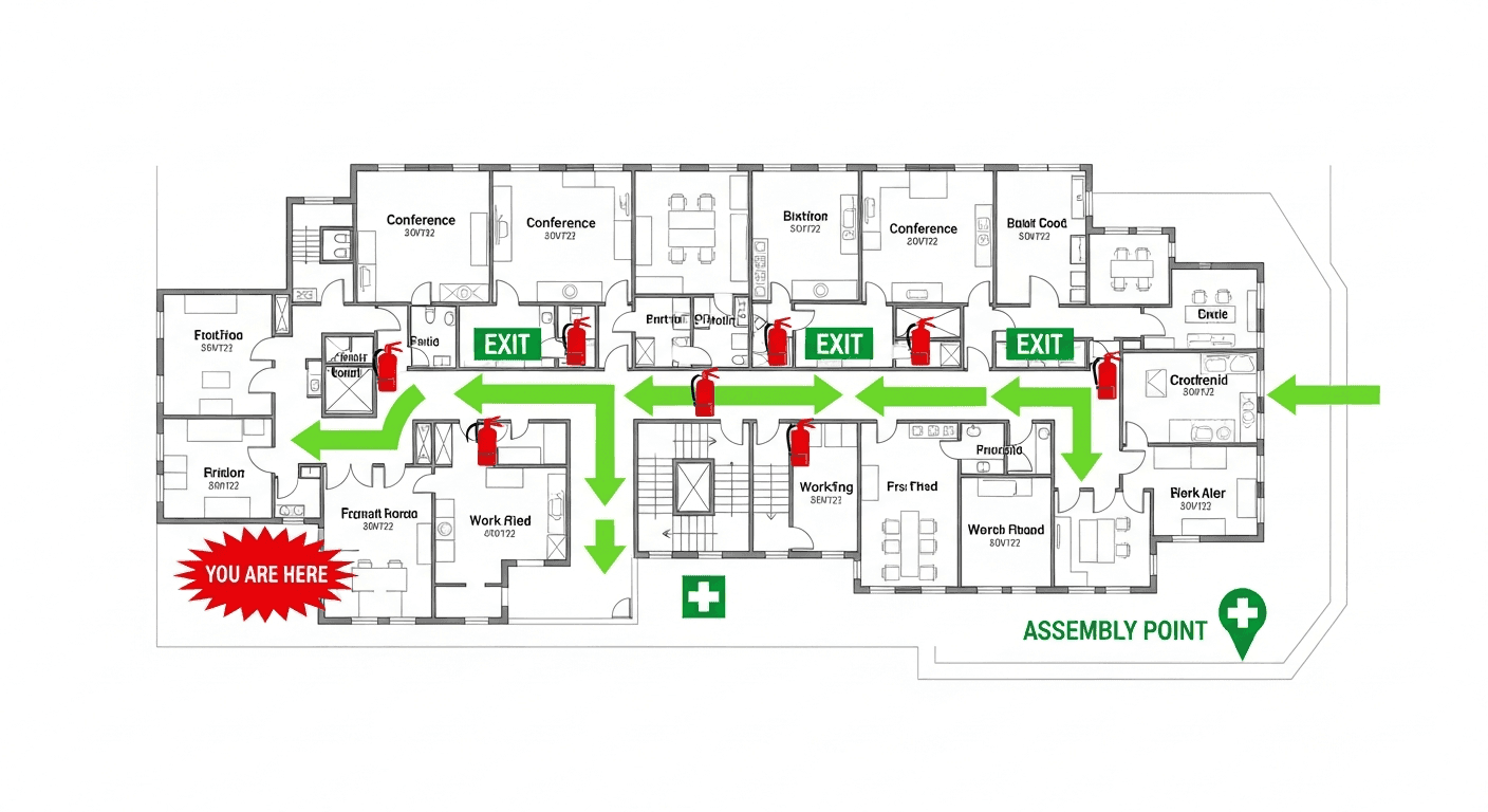
Sample Government OSHA-aligned evacuation floor plan showing emergency exits, fire extinguisher locations, and assembly points
🧯 Fire Extinguishers🚪 Exit Routes📍 You Are Here

No credit card required • Free account • Access your map drafts for review

Ready to Protect Your Government Facility?

Get your professional OSHA-aligned evacuation map in under 2 minutes.

Government OSHA Evacuation Map FAQs

What OSHA standards apply to government evacuation maps?
29 CFR 1910.38, Executive Order 12196 may be relevant starting points, but applicability depends on the facility's actual operations and hazards. 29 CFR 1910.38 applies only when another covered OSHA standard requires an Emergency Action Plan; more than 10 employees controls written versus oral form after that duty exists. Federal OSHA does not prescribe a universal evacuation-map checklist. Treat the generated map as a draft and verify OSHA, adopted-code, licensing, permit, insurer, and AHJ requirements separately.
What are the unique hazards in government that affect evacuation planning?
Government facilities may face hazards including security threats, public access areas, historic buildings. A site-specific hazard assessment and emergency plan should determine whether evacuation, shelter, shutdown, specialized routes, equipment, or assembly areas are appropriate. The generator can suggest visual elements, but a qualified reviewer must confirm them.
How often must government facilities update evacuation routes?
Review a map whenever layouts, exits, hazards, equipment, assembly points, or emergency procedures change. For a covered EAP, 29 CFR 1910.38 requires employee review when the plan is developed or changed and when responsibilities change; it does not establish a universal quarterly or annual map-update rule. Follow any additional adopted-code, permit, license, insurer, or facility cadence.
What training is required for government evacuation procedures?
Training and plan-review duties depend on the applicable standard and emergency plan. Under a covered 1910.38 EAP, employers review the plan with employees when it is developed, when responsibilities change, and when the plan changes. Federal OSHA does not impose one universal annual refresher rule for every government facility. Use only site-verified maps in training.
How do I create an evacuation map for my government facility?
Upload a floor plan, select "Government" as the industry type, and generate a map draft in under 2 minutes. Review the suggested routes, equipment, assembly point, scale, and floor geometry against the actual site, emergency procedures, and applicable requirements before use.
Are government evacuation maps suitable for fire inspections and OSHA audits?
A generated map is a draft, not proof of OSHA, fire-code, or inspection compliance. Have a qualified reviewer confirm the actual exits, routes, equipment, scale, occupancy, adopted code, and AHJ expectations. Portable-extinguisher travel-distance rules depend on the hazard class and program; they do not create a universal 75-foot map-symbol interval.
What emergency equipment must be shown on government evacuation maps?
There is no universal federal equipment-symbol checklist for government maps. Depending on the reviewed plan and adopted rule, a map may show verified extinguishers, alarms, exits, first-aid or AED locations, eyewash stations, or assembly areas. Include only current, site-verified items and confirm any required content with the AHJ.
How many emergency exits are required for government facilities?
29 CFR 1910.36 generally requires at least two exit routes, permits one where all employees can evacuate safely, and may require more depending on workplace size, occupancy, arrangement, and hazards. Adopted building and fire codes can add requirements. The generator suggests routes but cannot determine which exits are legally required or usable.
What special considerations exist for government evacuation plans?
Government planning may need to consider security threats and public access areas, equipment that can affect routes, shelter or shutdown procedures, accessibility, and responder coordination. A site-specific hazard assessment and qualified review—not the AI alone—must determine the appropriate procedures and routes.