AI-Powered Emergency Evacuation Map Creator

Emergency Evacuation Map Creator

Create professional, OSHA-compliant emergency evacuation maps in under 60 seconds. Our AI-powered emergency evacuation map creator transforms any floor plan—including hand-drawn sketches—into print-ready evacuation maps with clearly marked exit routes, fire safety equipment, and assembly points.

30 secMap Generation
100%OSHA Compliant
50+Industries

Free preview instantly. Register for 1 free file upload + 5 regenerations (no watermark).

3 Simple Steps:
1Upload Floor Plan
2Select State & Industry
3Get Your Map

Free Emergency Evacuation Map Creator

Upload your floor plan or hand sketch. Our AI-powered emergency evacuation map creator generates a professional, OSHA-compliant evacuation map instantly.

Loading Map Generator...

What is an Emergency Evacuation Map Creator?

An emergency evacuation map creator is a specialized software tool designed to generate professional, code-compliant evacuation maps from building floor plans. Unlike generic graphic design software, a dedicated emergency evacuation map creator understands OSHA requirements, fire safety codes, and ADA accessibility standards—automatically applying the correct symbols, route markings, and safety equipment placements.

Our AI-powered emergency evacuation map creator goes beyond simple templates. It analyzes your specific floor layout to identify optimal evacuation routes, calculates travel distances to exits, positions fire extinguisher markers within required 75-foot travel distances, and generates maps that meet OSHA 29 CFR 1910.38 Emergency Action Plan requirements.

Whether you're a facility manager creating maps for a single location, a safety consultant serving multiple clients, or a business owner ensuring compliance, our emergency evacuation map creator eliminates the need for expensive consultants or specialized design skills. Simply upload any floor plan—even a rough hand-drawn sketch—and receive a print-ready evacuation map in seconds.

Traditional Methods

  • Hire expensive consultants ($500-2000+)
  • Wait days or weeks for delivery
  • Limited revisions without additional cost
  • Manual compliance checking

Our Map Creator

  • Free to try, affordable plans available
  • Maps generated in 30-60 seconds
  • Unlimited regenerations included
  • Automatic OSHA compliance elements

OSHA Requirements for Emergency Evacuation Maps

Understanding federal workplace safety standards your evacuation maps must meet

OSHA 29 CFR 1910.38 - Emergency Action Plans

The Occupational Safety and Health Administration requires all employers with 10 or more employees to have a written Emergency Action Plan (EAP). While OSHA doesn't mandate a specific map format, your emergency evacuation map must effectively communicate evacuation routes as part of your EAP. Key requirements include:

  • Designated evacuation routes: Maps must show clear pathways from all occupied areas to emergency exits
  • Exit locations: All emergency exits must be clearly marked and identified on the map
  • Assembly points: Outdoor gathering locations where employees report after evacuation
  • Rescue and medical duties: Identify first aid station locations on your map
  • Employee alarm systems: Show fire alarm pull station locations

OSHA 29 CFR 1910.157 - Fire Extinguisher Placement

Fire extinguishers must be located within specific travel distances based on hazard classification. Your emergency evacuation map should show:

  • Class A hazards (ordinary combustibles): Extinguishers within 75 feet travel distance
  • Class B hazards (flammable liquids): Extinguishers within 50 feet travel distance
  • Class C hazards (electrical equipment): Based on Class A or B rating of the fire
  • Class D hazards (combustible metals): Within 75 feet of the hazard
  • Class K hazards (cooking oils/fats): Required in commercial kitchens

OSHA 29 CFR 1910.36 & 1910.37 - Exit Routes

These standards define requirements for exit route design and maintenance that your emergency evacuation map creator must account for:

  • Minimum two exit routes: Unless building size/occupancy allows single exit
  • Exit route width: Minimum 28 inches wide, doors 32 inches minimum
  • Exit discharge: Routes must lead directly outside or to a street
  • Exit signage: Illuminated EXIT signs at all designated exits
  • Emergency lighting: Adequate illumination along exit routes

Our emergency evacuation map creator automatically applies all OSHA requirements to your generated maps.

How to Create an Emergency Evacuation Map Step-by-Step

Complete guide to creating professional evacuation maps for your facility

1

Gather Your Floor Plan

Start with any representation of your building layout. This can be professional architectural drawings, CAD files, building blueprints, or even a hand-drawn sketch on paper. Our emergency evacuation map creator accepts:

  • JPG, PNG, or PDF images
  • CAD exports (DWG converted to image)
  • Photographed hand-drawn sketches
  • Building management system exports
2

Upload to the Map Creator

Access our free evacuation map generator above. Drag and drop your floor plan file or click to browse. Our AI immediately begins analyzing your layout, identifying:

  • Room boundaries and corridors
  • Door and window locations
  • Potential exit points
  • Stairwell and elevator positions
3

Select Industry & Location

Choose your industry type (office, warehouse, restaurant, healthcare, etc.) and state. This customizes your emergency evacuation map with:

  • Industry-specific safety equipment (e.g., Class K extinguishers for restaurants)
  • Specialized evacuation considerations (e.g., patient evacuation for healthcare)
  • State-specific compliance requirements
  • Relevant OSHA standard annotations
4

Generate Your Map

Click generate and our AI creates your evacuation map in 30-60 seconds. The emergency evacuation map creator automatically adds:

  • Primary exit routes (green arrows)
  • Secondary routes (yellow arrows)
  • Fire extinguisher locations
  • "You Are Here" markers
  • Assembly point designation
5

Review & Regenerate

Review your generated map. If needed, regenerate with additional instructions or adjustments. Free accounts include 5 regenerations per upload, allowing you to perfect your map. Check that all exits are properly marked and routes are optimal.

6

Download & Deploy

Download your print-ready evacuation map. Post maps at strategic locations per OSHA guidelines—typically at main entrances, near exits, in break rooms, and along primary corridors. Update maps whenever building layouts change.

Industry-Specific Evacuation Map Considerations

Each industry has unique safety requirements your emergency evacuation map must address

🏥

Healthcare Facilities

Hospitals, clinics, and nursing homes require specialized evacuation maps showing patient evacuation routes, areas of refuge for non-ambulatory patients, medical gas shutoff locations, and emergency power zones. Our healthcare evacuation map creator addresses these unique requirements.

🏭

Manufacturing Plants

Manufacturing facilities need evacuation maps showing hazardous material zones, LOTO (Lockout/Tagout) stations, chemical spill containment areas, machine guarding locations, and specialized PPE stations. See our manufacturing evacuation solutions.

🍽️

Restaurants & Food Service

Commercial kitchens require Class K fire extinguisher placement near cooking equipment, hood suppression system indicators, grease trap locations, and specific egress routes that avoid hot equipment. Our creator applies all fire exit map requirements for food service.

📦

Warehouses & Distribution

Warehouse evacuation maps must show dock exits, forklift traffic zones, rack sprinkler locations, high-pile storage areas, and emergency exits that account for aisle obstructions. Generate warehouse-specific maps instantly.

🏫

Schools & Educational

Educational facilities need evacuation maps for each classroom showing routes to designated assembly areas, special needs student considerations, lockdown vs. evacuation protocols, and parent pickup zones during emergencies.

🏨

Hotels & Hospitality

Hotels require room-by-room evacuation maps posted on guest room doors, floor-level maps in corridors, stairwell assignment for each floor, and accessible evacuation routes for guests with disabilities.

State-Specific Evacuation Map Compliance

Many states have requirements beyond federal OSHA standards

While OSHA sets the federal baseline for emergency evacuation maps, individual states may have additional requirements through their State Plan programs or local fire codes. Our emergency evacuation map creator allows you to select your state to apply relevant additional requirements.

California (Cal/OSHA)

Cal/OSHA Title 8 requires specific posting locations and bilingual evacuation maps in workplaces with significant non-English speaking populations.

Texas

Texas follows federal OSHA with additional requirements for high-hazard industries including oil & gas and chemical processing facilities.

New York

NYC has enhanced fire safety requirements including specific map posting heights and locations, particularly for high-rise buildings.

Florida

Florida requires evacuation maps to address hurricane and tropical storm scenarios in addition to fire evacuation routes.

Browse all 50 states to find specific evacuation map requirements for your location.

Complete Guide to Emergency Evacuation Map Creation

Why Every Workplace Needs a Professional Emergency Evacuation Map

Emergency evacuation maps serve as critical life-safety documents in workplaces across the United States. When fire alarms sound or emergencies occur, employees and visitors rely on clearly posted evacuation maps to navigate quickly and safely to exits. According to OSHA, proper emergency action plans—including well-designed evacuation maps—can significantly reduce injury rates during workplace emergencies.

An effective emergency evacuation map creator eliminates the guesswork from map creation. Rather than relying on generic templates or expensive consultants, businesses can generate customized, code-compliant maps tailored to their specific floor layouts and industry requirements. This democratization of safety compliance helps small businesses achieve the same level of protection as large corporations.

Key Elements of OSHA-Compliant Evacuation Maps

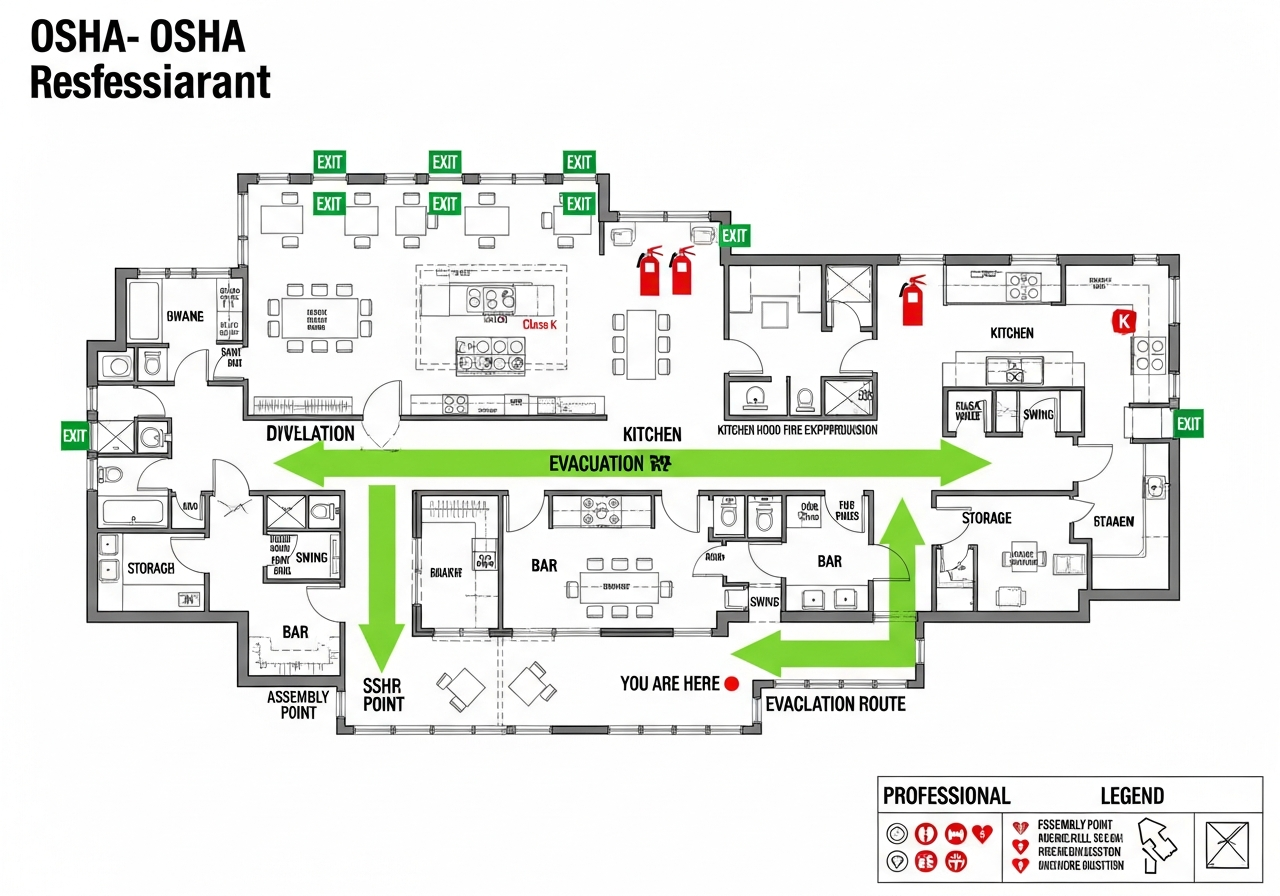
A comprehensive emergency evacuation map must include several critical elements to meet OSHA requirements and effectively guide occupants during emergencies:

Primary and Secondary Exit Routes: Maps must clearly show the primary evacuation path from each area, typically marked with green arrows. Secondary or alternate routes should be indicated with yellow or orange arrows, providing options if primary routes are blocked.

"You Are Here" Indicators: Each posted map should include a clear marker showing the viewer's current location, enabling quick orientation and route selection.

Fire Safety Equipment: Fire extinguisher locations must be marked, with OSHA requiring Class A extinguishers within 75 feet travel distance in most workplaces. Fire alarm pull stations and AED locations should also be indicated.

Assembly Points: Maps should indicate outdoor assembly areas where employees gather after evacuation, enabling headcounts and ensuring everyone has safely exited.

Accessible Routes: ADA-compliant routes for individuals with mobility impairments must be shown, including areas of refuge where individuals can await assistance if needed.

The Role of Technology in Modern Evacuation Map Creation

Traditional evacuation map creation required hiring architects, safety consultants, or graphic designers—often costing $500 to $2,000 or more per map. Modern AI-powered emergency evacuation map creators like ours have transformed this process, making professional-quality maps accessible to all businesses regardless of size or budget.

Our AI analyzes floor plan images using computer vision technology, identifying walls, doors, corridors, and potential exit points. It then applies OSHA requirements and industry best practices to generate evacuation routes, position safety equipment markers, and create print-ready maps in seconds rather than days.

Posting and Maintaining Emergency Evacuation Maps

Creating the map is only the first step. OSHA and fire codes require evacuation maps to be posted at specific locations:

  • Building entrances: Main entry points where employees and visitors first enter
  • Near elevators and stairwells: Key navigation points in multi-story buildings
  • Break rooms and common areas: High-traffic locations where employees gather
  • At exit doors: Confirming proper exit routes at discharge points
  • Guest rooms (hotels): Posted on the back of guest room doors

Maps must be updated whenever floor layouts change, exits are modified, or safety equipment is relocated. With our emergency evacuation map creator, updates take less than 60 seconds—simply upload the new floor plan and regenerate.

Integration with Emergency Action Plans

Your emergency evacuation map should be part of a comprehensive Emergency Action Plan (EAP) as required by OSHA 29 CFR 1910.38. The EAP should include:

  • Procedures for reporting fires and emergencies
  • Evacuation procedures and emergency escape routes (your evacuation maps)
  • Procedures for employees who remain to perform critical operations
  • Accounting for all employees after evacuation
  • Rescue and medical duties for designated employees
  • Names or job titles of persons to contact for plan information

Use our OSHA Emergency Action Plan Template to create a complete EAP that incorporates your evacuation maps.

Frequently Asked Questions About Emergency Evacuation Map Creation

What is an emergency evacuation map creator?

An emergency evacuation map creator is a specialized tool that generates professional, OSHA-compliant evacuation maps from floor plans or sketches. Our AI-powered emergency evacuation map creator transforms any input—hand-drawn layouts, PDFs, or CAD files—into print-ready evacuation maps with clearly marked exit routes, fire extinguisher locations, assembly points, and all required safety elements within 30-60 seconds.

How do I create an evacuation map using your emergency map generator?

Creating an evacuation map is simple: (1) Upload your floor plan image, PDF, or hand-drawn sketch to our emergency evacuation map creator. (2) Select your industry type and state for customized compliance requirements. (3) Our AI analyzes your layout and generates a professional evacuation map with exit routes, safety equipment, and assembly points. (4) Download your print-ready map instantly. The entire process takes under 60 seconds.

What OSHA requirements must emergency evacuation maps meet?

OSHA 29 CFR 1910.38 requires emergency action plans with evacuation routes for all workplaces with 10+ employees. Your emergency evacuation map must include: clearly marked primary and secondary exit routes, emergency exit locations, fire extinguisher placements within 75ft travel distance (OSHA 1910.157), fire alarm pull stations, assembly point locations, 'You Are Here' indicators, and ADA-accessible routes. Our emergency evacuation map creator automatically includes all these elements.

Is this evacuation map creator really free to use?

Yes! You can preview maps instantly with a watermark for evaluation. Register for a FREE account (30 seconds, no credit card) to get 1 free file upload with 5 regenerations and no watermark. Your maps are saved to a personal dashboard for easy access. Enterprise features are available for businesses needing bulk map generation.

Can I create evacuation maps for different building types?

Absolutely. Our emergency evacuation map creator supports 50+ industry types including offices, warehouses, restaurants, healthcare facilities, retail stores, manufacturing plants, schools, hotels, and more. Each industry has specialized OSHA requirements—for example, restaurants need Class K fire extinguisher placement near cooking equipment, while warehouses require dock exit markings and forklift path indicators.

What file formats can I upload to the evacuation map creator?

Our emergency evacuation map creator accepts virtually any format: JPG, PNG, PDF, hand-drawn sketches photographed on your phone, CAD exports, architectural drawings, or rough napkin sketches. Our AI is trained to understand floor layouts regardless of input quality, making it easy to create evacuation maps without professional design software.

How often should I update my emergency evacuation maps?

Update your evacuation maps whenever: floor plan changes occur (walls added/removed, exits modified), occupancy or use changes, fire safety equipment is moved, emergency procedures are modified, or annually as part of routine safety audits. With our emergency evacuation map creator, updates take under 60 seconds—just upload the new floor plan and regenerate.

Do different states have different evacuation map requirements?

Yes, while OSHA sets federal baseline requirements, many states have additional regulations. California (Cal/OSHA), New York, Texas, and other states may require specific elements or posting locations. Our emergency evacuation map creator allows you to select your state to apply state-specific compliance requirements automatically.

What elements are included in generated evacuation maps?

Every map from our emergency evacuation map creator includes: primary exit routes (green arrows), secondary/alternate routes (yellow arrows), 'YOU ARE HERE' markers, fire extinguisher locations with 75ft coverage circles, fire alarm pull stations, first aid kit locations, ADA-accessible routes, outdoor assembly points, emergency contact information, and industry-specific safety equipment relevant to your building type.

Can I create an evacuation map from a hand-drawn sketch?

Yes! Our emergency evacuation map creator specializes in transforming hand-drawn sketches into professional, compliant evacuation maps. Simply draw your floor layout on paper showing walls, doors, and major features. Take a photo with your phone and upload it. Our AI interprets your sketch and generates a polished, print-ready evacuation map with all required safety elements.

Ready to Create Your Emergency Evacuation Map?

Join thousands of businesses using our emergency evacuation map creator for OSHA compliance.

Free preview instantly. Register for 1 free file upload + 5 regenerations (no watermark). No credit card required.