(775) 317-4488|Need help with your map? Call or chat with us!support@oshamap.com
USE CASE
🏛️

Evacuation Maps for Government Buildings

Public sector evacuation compliance

Last reviewed: June 8, 2026 · Reviewed by OSHAMap Safety Editorial Team · Review with a qualified safety professional when required.

Government facilities must meet stringent safety requirements and serve diverse public populations. OSHAMap addresses public sector evacuation needs.

Generate your map in under 2 minutes

FROM FLOOR PLAN TO REVIEW-READY DRAFT

Keep the building familiar.
Make the safety story legible.

OSHAMap turns the layout you already have into an editable OSHA-aligned draft—so a safety professional can focus on verification, not redrawing.

01 / SOURCE

Start with what you have.

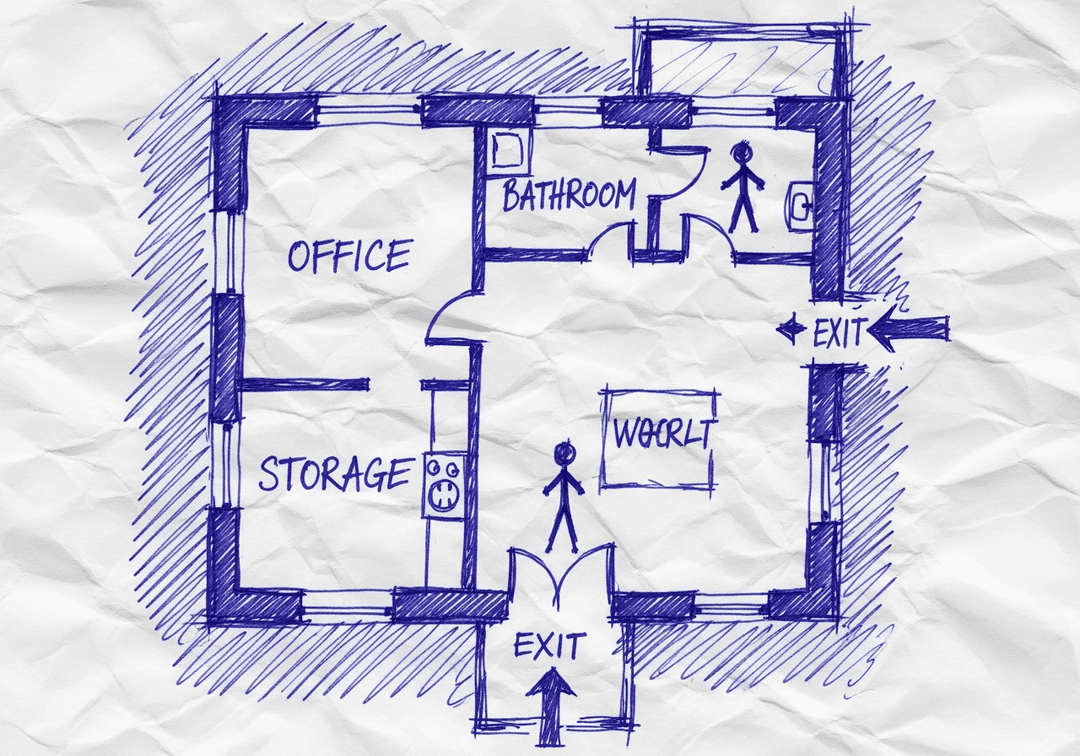
A floor-plan PDF, phone photo, or hand sketch gives the draft a place to begin.

Upload PDF, image, or sketchEditable safety elementsExport after review
YOUR SOURCE
Hand-drawn workplace floor planPDF · photo · sketch
ILLUSTRATIVE EDITABLE DRAFT
The same hand-drawn workplace floor plan with an illustrative editable safety layer
Review before posting
Built for reviewConfirm site-specific routes and equipment.
Designed to editMove, resize, and adjust visual safety elements.
Ready to shareExport the reviewed draft as PDF, PNG, or SVG.

AI Creates the Draft. Your Safety Team Makes It Site-Ready.

Faster first drafts. Human-reviewed decisions. Safer U.S. workplaces.

INSIDE THE EDITING EXPERIENCE

AI creates the first draft.Your team stays in control.

The automation gets you to a strong starting point. The editor keeps your team in control of site-specific details.

WALKTHROUGHEvacuation map · editable draft
EDITABLE DRAFT
REVIEW CHECKVerify exit routeConfirm this path reflects the current facility.READY FOR REVIEW
EXPORT REVIEWED DRAFT
PDFPNGSVG

01 / 04 · Open draft

Your generated draft opens in the editor.

Start from the OSHA-aligned map draft and keep the building layout in view while you review each safety element.

OSHAMap creates an OSHA-aligned draft for review. Your safety team or AHJ should verify the final map before posting.

Designed for Government Buildings

Do I need design skills to create an evacuation map?

No design skills are required. Our AI understands hand-drawn floor plans, smartphone photos, scanned blueprints, and PDF documents. Simply upload any representation of your facility layout and receive a professional-grade emergency evacuation map instantly.

Are the generated maps OSHA-aligned?

OSHAMap is designed to help users organize key evacuation-planning information commonly associated with OSHA 29 CFR 1910.38 — clearly marked exit routes, fire extinguisher locations within 75-foot travel distance, assembly points, YOU ARE HERE markers, and accessibility accommodations per ADA guidelines. Each draft must be reviewed and verified for the actual workplace by the employer, safety officer, or AHJ before posting.

Can I update my evacuation map after renovations?

Yes. If you renovate your office or add an emergency exit, re-upload the updated floor plan and create a new draft for review. Free accounts include up to 5 regenerations per upload; verify each revision against the workplace before posting.

What types of buildings can use this evacuation map generator?

Our generator works for any building type including warehouses, manufacturing plants, healthcare facilities, schools, retail stores, and office buildings. The AI adapts to any facility size and layout, generating appropriate exit routes, fire safety equipment placement, and assembly point locations.

Create Your Government Buildings Evacuation Map

Upload your floor plan and get a professional OSHA-aligned evacuation map in under 2 minutes

📊 5 Free Maps Left

Create Your Government Buildings Evacuation Map

See the safety plan from every angleWatch a sketch become a polished map, then step inside.Watch demo Need to start from a rough layout?Sketch rooms and exits, then turn it into a clear safety map.Draw your map
✏️
High ContrastUse dark ink on white paper. Bold lines help our AI detect walls accurately
📐
Top-Down AnglePhotograph from directly above — tilted angles distort the geometry
🏷️
Label RoomsWrite "Exit", "Storage", "Breakroom" etc. — our AI reads your labels for compliance
🔍
Full Floor PlanCapture the entire layout including all walls, doors, and exits — no cropping
🚪
Mark ExitsCircle or label exit doors with a red dot or "EXIT" text for best detection
💡
Good LightingAvoid shadows and glare — even lighting produces the sharpest results
📁

Drag & drop your floor plan here

or

PNG, JPG, HEIC, TIFF, BMP, SVG, AVIF, WebP, PDF, DOC, DOCX, PPT, PPTX, XLS, XLSX, ODT, ODP, ODS, DXF, DWG - Hand-drawn sketches work too!

or

No floor plan handy? Try the included floor plan with real AI generation — no upload needed. This may take a minute or longer.

Edit your map for free.
Move, resize, and recolor every exit sign, route, and icon.
Create a free account to save and download in HD. No credit card required.
FREE
🔒Your files are private: never shared, stored temporarily, deleted automatically.

Compliance Options

🔥 NEW✨

Customize Your Map

Add special requests for your safety map - tell our AI exactly what you need!

  • 🎯Add specific details like "Mark fire extinguisher near kitchen"
  • 📍Request specific zones: "Highlight assembly point in parking lot"
  • 🏥Add safety equipment: "Include AED location near reception"
0/2000

Quick Add:

Automatic (recommended)

Redraw the architecture from your floor plan first, then add editable safety markings. The original upload remains a reference, not the map background.

Frequently Asked Questions

Is this evacuation map generator really free?

Yes — you can generate your first OSHA-aligned evacuation map draft completely free. Just upload a floor plan and our AI drafts a professional map in about 30 seconds. No credit card required.

Are the generated maps aligned with OSHA?

Our AI drafts maps that follow OSHA 29 CFR 1910.36–37 and NFPA 101 Life Safety Code standards. Every map includes clearly marked exits, fire extinguisher locations, assembly points, and directional evacuation arrows. Supervisor review is required before posting to your facility.

What file formats can I upload?

We accept PNG, JPG, GIF, WebP, BMP, TIFF, AVIF, HEIC, SVG, PDF, DOC/DOCX, PPT/PPTX, XLS/XLSX, ODT, ODP, ODS, DXF, and DWG floor plans. Office and CAD files are converted securely before processing; PDF uploads let you choose the source page.

How long does map generation take?

Most maps are generated in 20–40 seconds. Complex multi-floor plans may take slightly longer. You see the preview instantly — create a free account (no credit card) to download the file.

Can I edit the map after generation?

Yes — every generated map opens in a free drag-and-drop editor where you can move, resize, and recolor exit signs, routes, and equipment icons. Enterprise features like multi-floor support and branded maps are available on paid plans.

Is my floor plan data secure?

Yes. All uploads are encrypted in transit (TLS 1.3) and processed in secure cloud environments. We do not share your floor plans with third parties.

Use Case Deep Dive

Public Sector Safety Excellence

Tailored solutions for government buildings environments

Operational Outcomes by Persona

👤

Facility Director

Pain Point: ADA accessibility requirements
Solution: Fully accessible route marking
100% ADA compliant routes
👤

Safety Officer

Pain Point: Public access considerations
Solution: Citizen-friendly wayfinding
Public knows all exits
👤

Security Chief

Pain Point: Security and safety balance
Solution: Security-integrated evacuation
Both priorities addressed
👤

Budget Director

Pain Point: Cost-effective compliance
Solution: Affordable professional maps
Budget-friendly solution

Execution Playbook

Public Areas
Map all citizen-accessible spaces
Public wayfinding
Week 1
Staff Areas
Offices and work areas
Employee routes
Week 2
Secure Areas
Restricted zones
Security-aware routing
Week 3
ADA Review
Verify accessible routes
Accessibility symbols
Week 4

Success Stories

County Government Complex
Challenge: ADA compliance audit findings
Result: All accessible routes properly marked
City Hall
Challenge: Public safety during renovations
Result: Updated maps for each construction phase

Perfect for Government Buildings

Get your tailored evacuation map designed exactly for your situation. Ready in 2 minutes.

No credit card required

Unique Challenges for Government Buildings

⚠️Public access requirements
⚠️Security integration
⚠️Accessibility mandates
⚠️Budget constraints

How OSHAMap Solves Them

✓ADA-compliant design
✓Security-aware routing
✓Accessible route marking
✓Cost-effective compliance

Benefits for Government Buildings

✓Public safety
✓Regulatory compliance
✓Accessibility
✓Budget efficiency

Key Statistics: Government Buildings

Understanding the numbers behind government buildings helps prioritize your safety planning.

1 in 59Inspection ProbabilityEmployers face random OSHA inspections
$16,550Average Violation FinePer serious OSHA violation
2.8 millionWorkplace InjuriesAnnual preventable injuries
SignificantGovernment Buildings ImpactDirectly affects compliance and safety

Implementation Guide: Government Buildings

Follow this step-by-step process to address government buildings effectively.

1

Assess Your Space

Evaluate your government buildings layout for evacuation route needs and hazard areas.

⏱️ 20 minutes
2

Document Current Layout

Photograph or sketch your floor plan showing exits, hazards, and key areas.

⏱️ 15 minutes
3

Generate Custom Map

Upload to OSHAMap for government buildings-specific evacuation map.

⏱️ 2 minutes
4

Add Industry Details

Mark government buildings-specific hazards and equipment locations.

⏱️ 10 minutes
5

Deploy Maps

Print and post maps at all exits, break areas, and high-traffic locations.

⏱️ 30 minutes
6

Train Staff

Conduct government buildings-specific evacuation training for all employees.

⏱️ 1 hour

Traditional vs. OSHAMap

See how AI-powered evacuation maps outperform traditional methods for government buildings.

AspectTraditional MethodsOSHAMap
Time to Complete3-6 weeks2 minutes
Cost per Map$500-$2,000Free preview
Government Buildings ExpertiseAdditional research requiredBuilt-in industry knowledge
Hazard RecognitionManual identificationAI-assisted hazard marking
Compliance AssuranceVaries by consultantFull OSHA compliance
UpdatesNew project, new feesInstant regeneration

Government Buildings Compliance Checklist

Use this checklist to ensure you've covered all aspects of government buildings.

✓ADA-compliant design
✓Security-aware routing
✓Accessible route marking
✓Cost-effective compliance
✓Public safety
✓Regulatory compliance
✓Accessibility

Cost-Benefit Analysis

Compare the true costs of different approaches to government buildings.

ItemTraditional ApproachWith OSHAMap
Professional Map Creation$500-2,000Free preview
Time to Delivery3-6 weeks waiting2 minutes
Revision Costs$100-300 per changeUnlimited free revisions
Annual Maintenance$300-500Generate new map anytime
Government Buildings ComplianceAdditional consultingBuilt-in expertise

Expert Tips for Government Buildings

💡

Update evacuation maps within 30 days of any layout changes per OSHA requirements.

— 29 CFR 1910.38
💡

Post maps at eye level near exits and in high-traffic areas for maximum visibility.

— NFPA Life Safety Code
💡

Conduct evacuation drills at least annually and document results for compliance records.

— OSHA Best Practices

Real-World Application

📋

Case Example: Government Buildings

Scenario

A government buildings needed to create OSHA-aligned evacuation maps for their space.

Challenge

Public access requirements

Solution

ADA-compliant design

Outcome

Public safety

Role-Based Insights

Persona-Specific Guidance

Tailored information for different stakeholders

Key Challenges

  • Maintaining compliance across multiple facilities
  • Standardizing safety protocols
  • Proving ROI on safety investments
  • Managing regulatory relationships
  • Addressing government buildings requirements

Top Priorities

  • Zero citation track record
  • Proactive compliance posture
  • Employee safety culture
  • Audit readiness

Common Objections

  • Our current system works fine
  • Change management is difficult
  • Not in this year's budget

How We Address Them

  • AI tools integrate seamlessly
  • Implementation takes hours not weeks
  • First map is free to prove value
  • Commercial properties manage diverse tenant needs

Success Metrics for Safety Director

Inspection pass rate
Citation avoidance
Training completion rate
Drill performance scores

Implementation Examples

Post-incident remediation for Government Buildings

Facility recovering from OSHA citation. Multi-tenant coordination.

Steps:
  1. Immediate citation response
  2. Comprehensive gap analysis
  3. Compliant map generation same-day
  4. Documentation for abatement
  5. Follow-up verification
Outcome: Citation abated within penalty deadline, zero repeat findings on follow-up inspection
⏱️ Same-day response, ongoing sustainment

Insurance renewal preparation for Government Buildings

Organization facing premium increase. Multi-tenant coordination.

Steps:
  1. Carrier requirement documentation
  2. Professional map generation
  3. Training record compilation
  4. Submission to underwriter
Outcome: Demonstrated compliance resulted in 8% premium reduction, $23,000 annual savings
⏱️ 4-week preparation cycle
⚠️ OSHA COMPLIANCE ALERT

OSHA Compliance Alert: Government Buildings

Over 52,548 OSHA violations issued nationally. Average penalty: $16,550 per serious violation.

🔍31,822Annual Inspections
⚠️52,548Violations
💰$189.4MTotal Penalties
💀5,486Fatalities
🚨

OSHA Penalty Structure - Know Your Risk

Other-than-SeriousUp to $16,550Per violation
Serious ViolationUp to $16,550Per violation
Willful / RepeatUp to $165,514Per violation
Failure to Abate$16,550/dayAfter citation deadline

Avoid costly penalties with compliant evacuation maps

⚠️

Top OSHA Violations in nationwide

Is your facility compliant?

🗺️

Missing Evacuation Maps = OSHA Violation

29 CFR 1910.38 requires emergency action plans with posted evacuation routes. Generate compliant maps in minutes.

⏰Don't Wait for an OSHA Inspection

Get Your your area Evacuation Map Today

Professional, OSHA-aligned maps generated in minutes. Avoid penalties up to $165,514 per violation.

View Pricing
✓ OSHA-Aligned✓ Print Ready✓ AI-Powered✓ Used by 47,000+ Businesses
🔓 Free Account Bonus

Unlock 5 Free Floor-Plan Uploads Per Month

Create your free account to access professional, OSHA-aligned evacuation-map drafts for review.

What You Get When You Register:

  • ✓ 5 Free Floor-Plan Uploads Per Month + Up to 5 Regenerations Per Upload - Professional maps ready for printing
  • ✓ No Watermarks - Clean, presentation-ready evacuation maps
  • ✓ Personal Dashboard - Manage all your maps in one place
  • ✓ Save & Revisit Anytime - Access your maps from any device
  • ✓ OSHA-Aligned - Meets 29 CFR 1910.38 requirements
15,000+Maps Generated
100%Compliant
Sample Output
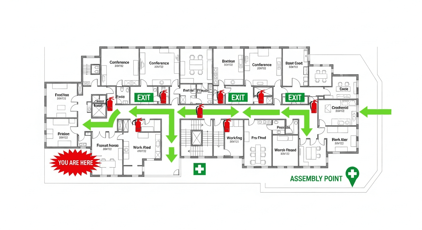
Sample Government Buildings OSHA-aligned evacuation floor plan showing emergency exits, fire extinguisher locations, and assembly points
🧯 Fire Extinguishers🚪 Exit Routes📍 You Are Here

No credit card required • Free account • Access your map drafts for review

Perfect for Government Buildings

Get professional evacuation maps designed for your specific environment.